Lake water levels are always a concern to cottagers. We are fortunate that Chandos is an unregulated lake, because many lakes in the area are reservoir lakes for the Trent Severn Waterway, and are thus susceptible to large swings in level as the TSW commission attempts to keep the Waterway navigable.
Extreme manipulation (or abnormal natural fluctuation) of lake levels can have environmental costs, especially significant drawdowns in the fall, or deliberately high waters in the spring implemented to control downstream flooding. Fish spawning grounds, bird nesting sites, and various other biota that play a role in the overall ecosystem can be disrupted. There is a dam at the outlet of Paudash lake, which controls the flow down the Crowe River. The operation of this dam can impact Chandos Lake.
Chandos is somewhat unique in that its only outlet, Flat Creek, which connects Chandos to the Crowe River, can reverse when the Crowe is higher than the lake. This can occur in the spring, especially when there is a quick melt and the Crowe/Paudash watershed has a lot of snowpack.
The steady state level of Chandos is governed by:
- the height of the outlet, ie the silt level in the culverts.
- the level of the Crowe River at the confluence with flat Creek. (which in turn is affected by the operation of the Paudash dam)
- the amount of obstruction to flow along Flat Creek and how it changes with the lake level
- The head (difference in elevation between the lake and the confluence). necessary to bring the inflow and outflow into equilibrium.
- The height of the water table that feeds groundwater into the lake.
In the spring, when there is a reversal of Flat Creek and water is temporarily flowing in from the Crowe, the situation is very dynamic in that a lot of variables interact. Some recent modelling of these relationships has yielded some interesting results, in particular that if the lake is drawn down, let us say one foot in the fall, then the next spring highwater mark will not be one foot lower, but perhaps only 4″ lower. This is because a lower starting level for the lake will allow for more water to come in from the Crowe, and also more time for the Chandos runoff to accumulate before Flat Creek starts taking it away.. (It should be emphasized that a model is only as good as its assumptions, and that these results are preliminary as the modelling work is ongoing.)
Reviewing historical data has shown the following:
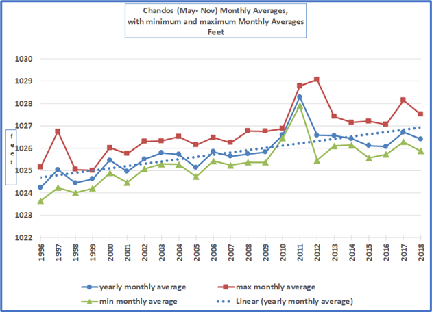
i) There have always been highwater events in the spring, and the situation is no different today. Some of the early data regarding the high water mark is suspect, perhaps due to faulty gauge operation, but there are some somewhat credible historical highs over 1029 feet in 1994, 2011, and 2012, as recorded by the CVCA at the Culvert Gauge.
ii) In general, the summer lake levels are about 2 feet higher than they were 20 years ago, and this is believed to be the result of the culverts silting up. There may also be increased obstruction along Flat Creek limiting the rate of outflow. Many long-time cottager have attested to the fact that the summer levels used to be lower.
It should be noted that while some folk prefer lower levels, others prefer higher ones. Lower levels create beaches, but expose more boating rock hazards, and increase weed growth. Higher levels make for better swimming and docking, but contribute to shoreline erosion.
Another issue that needs more investigation is how the operation of the Paudash dam affects Chandos Lake. The Crowe River originates at Paudash Lake, and the purpose of the dam is to regulate the level of Paudash, as well to manage for flood control along the Crowe. When the level at the confluence of the Crowe and Flat Creek exceeds that of Chandos, then Flat Creek reverses, thereby increasing the level of Chandos. In that instance it can be said that Chandos acts as a reservoir for the Crowe River.
A more comprehensive look at Chandos water levels can be found here.
Chandos Low Water Situation of 2025
Over the summer of 2025 there was very little rain, coupled with a lot of hot and sunny days. The lake level dropped significantly compared to recent years, and this has been attributed to a drop in the water table. For more info, go here.
